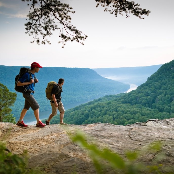
take a hike!
Get out in the Gorge and explore.

Trails in the Gorge

Aetna Mountain Trails
The Aetna Mountain Trails are multi-use trails for mountain bikers and hikers that include a total of 4 miles. The trails are divided into two loops: one beginner friendly green loop and one intermediate to advanced blue loop. The trails take hikers through along the side of Aetna Mountain through a beautiful hardwood forest and past mountain streams.

Ritchie Hollow Trail
The Ritchie Hollow Trail will be CLOSED for Prentice Cooper Wildlife Management Area hunts on these dates in 2026: April 14-16, April 17-19, April 22-24, April 30 - May 2, May 5-7, May 8-10
The Ritchie Hollow Trail is an approximately 2.7 mile trail (one-way) that ties the Tennessee River to the top of Suck Creek Mountain and the Davis Pond parking area and campsite on Prentice Cooper State Forest. The trail also crosses the Cumberland Trail system’s Pot Point Loop 2.2 miles from the lower trailhead parking area.

Pot Point Nature Trail
The Pot Point Nature Trail is a 4.1 mile loop trail featuring a mature hardwood forest, a path through the Trust's butterfly garden, and a long stretch near the Tennessee River.

Edwards Point
Edwards Point is a scenic overlook on the bluff of Signal Mountain that sits off the Cumberland Trail. The viewshed includes downtown Chattanooga, Middle Creek, and Williams Island to the east. To the west is the heart of the Tennessee River Gorge

Stringer's Ridge Trails
Stringer's Ridge is a 92-acre urban park located in downtown Chattanooga. The ridge contains 3 trail loops, totaling 10 miles of trails.

Raccoon Mountain Trails
A 15-minute drive from downtown, you can enjoy the 13-mile trail running loop or nearly 30 miles of mountain biking single track. Your choice.
Prentice Cooper Trails
Only 10 miles west of Chattanooga, and popular for hunting, climbing, mountain biking, horseback riding, camping, hiking, and trail running, Prentice Cooper is an absolute gem.
Prentice Cooper State Forest and Wildlife Management Area will be holding managed hunts on the following 2026 dates. [On these dates the area west of state highway 27 (Suck Creek Road) will be closed to all visitors except licensed hunters. The area east of state highway 27, Edward’s point, will remain open to visitors.] April 14-16, April 17-19, April 22-24, April 30 - May 2, May 5-7, May 8-10

Signal Mountain Trails
Experience the beauty of the Cumberland Trail, punctuated by magnificent views of the Tennessee River Gorge.